Personalize
Working with layers and map contents
This application can use one or more content sources.
Each content item corresponds to a service,
such as an ArcGIS Server service.
Each source contains one or more map layers.
A map layer is a type of data shown on the
map, such as roads, cities or a aerial images.
To examine the map contents:
- If map content is not visible, or if you want to add or subtract data then click on layer Widget.
 .
.
- When Map Contents opens, only the top-level content items may be visible.
Click the right arrow button next to a content item to display the layers within it, as shown below.
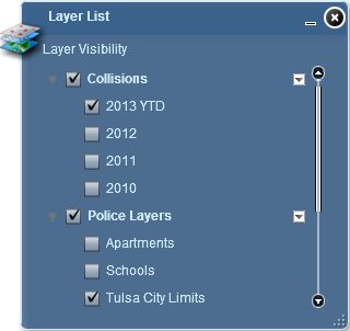
- A check-box next to the layer indicates whether
the layer is currently turned on.
- The check-box also indicates whether the layer is not displayed on the map
due to scale dependancy
- You can click the check-box next to
the layer name to turn the layer on or off.
The map automatically redraws to reflect the
changes in layer visibility.
- Some layers may not be visible at the current map
scale (zoom level). These layers are called
scale dependent. You may need to zoom the map
in or out to see a particular layer displayed,
even if its check-box is checked to draw.